In emergency situations, knowing the exact location of the person in need is crucial. This is not just about dispatching resources, but also about routing the emergency conversation to the most appropriate PSAP in the first place.
This is where PIDF-LO comes into play. PIDF-LO stands for Presence Information Data Format – Location Object
In summary, the Presence Information Data Format – Location Object is a standardized format for representing location information in a versatile and comprehensive manner. It supports a wide array of use cases, making it flexible enough to convey location details for addresses, persons, alarms, devices, etc. PIDF-LO provides a consistent method for representing location data across various scenarios. It is worth mentioning that PIDF-LO is not restricted to representing the location of a person in distress, but can represent location information for any entity including locations of CCTV cameras, alarm sensors, restricted areas etc. It’s a key part of how modern emergency systems and services exchange location information in a standardized way within the Next Generation 112 (NG112) architecture and the ETSI TS 103 479 standard.
In this blog post, we’re diving into the details of PIDF-LO. We’ll explore how location information is technically represented and how it can be exchanged by different systems and services.
Presence Information Data Format – Location Object
In general, location information can primarily be categorized into two formats: geodetic and civic (address).
The geodetic format utilizes geographical coordinates to describe a location through different shapes such as points, circles, arc bands, and polygons. This method provides a precise mathematical representation of a location on the Earth’s surface, allowing for exact pinpointing and area specification.
On the other hand, the civic address format represents location through addresses, offering a human-readable form that includes cities, street names, house numbers and other relevant postal information often referred to as “dispatchable location”.
It is worth noticing that PIDF-LO is not limited to a single format, but can provide geodetic and civic address information at the same time.
Geodetic Representation
When describing location information in the geodetic format, the PIDF-LO technically embeds geometries specified by the opengis.net namespace in order to reuse existing standards in the industry.
Leveraging those formats, it allows geodetic location information to be represented as:
- Point (2d and 3d)
- Polygon (2d)
- Circle (2d)
- Ellipse (2d)
- Arc band (2d)
- Sphere (3d)
- Ellipsoid (3d)
- Prism (3d)
Considering the current situation and geodetic location sources, the most commonly used ones are Point, Circle and Arc Band. Point and Circle are often used to pinpoint the location of the person in distress, e.g. to represent the location provided by Advanced Mobile Location (AML), while Arc Band can be used to describe the general coverage area of a cell tower.
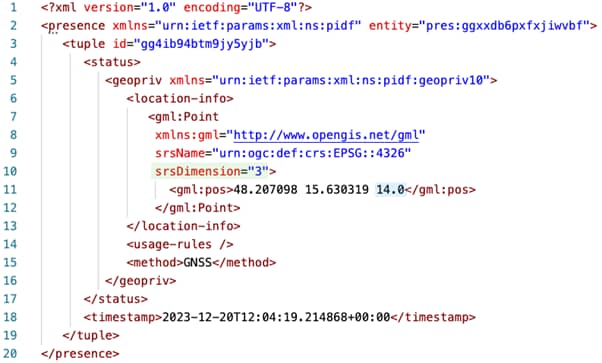
3-dimensional geometries additionally provide the ability to represent the elevation, which is especially important in places with lots of “layers”, like bridges and overpasses. Usually only less complex 3-dimensional geometries are used in the context of emergency services and complex ones, such as Ellipsoid or Prism, are less common. In the following example you see a 3 dimensional point (indicated by the srsDimension in green highlighted) as well as a third coordinate in addition to latitude and longitude (blue highlighted) specifying the elevation in meters.
Civic Address Representation
Representing location information as an address is a common and intuitive method, especially in emergency situations where quick comprehension is crucial. Addresses, composed of elements like street names, numbers, city, and sometimes additional details such as apartment numbers, provide a direct and user-friendly way to communicate location.
This method is particularly advantageous in urban areas, where addresses are well-defined and familiar to both the caller and the emergency services. It facilitates a straightforward dispatch of help to the caller’s location, as addresses are easily recognized and navigated by response teams.
The PIDF-LO provides the capabilities to represent location information in the form of a civic address including additional details, such as room, floor number etc.
PIDF-LO Examples
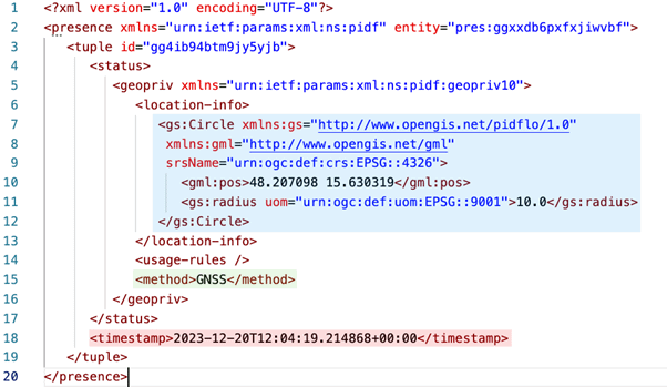
Basic Circle
The following shows an example PIDF-LO representing geodetic location information in the geometry of a circle (blue highlighted). In addition to the timestamp (red highlighted) it also includes the method of positioning (green highlighted).
Basic Civic Address
The next example shows a PIDF-LO representing location information in the form of an address. The civicAddress element contains multiple values, including the country, road (RD), house number (HNO), postal code (PC) and floor number (FLR). The values A1-A6 can be used as national subdivision identifiers. In this particular example, Vienna as the capital city of Austria is special as it is also the political district and even the province. However, Vienna has 23 different districts, which is represented as the value of A4 (1 = First District).

Exchange
It is important to understand that while PIDF-LO is the standardized representation of location information, its transmission can be realized in multiple ways. In the following we will have a look at the transmission of PIDF-LO as part of the Session Initiation Protocol (SIP) as well as part of the Location Information Service (LIS) embedded in the HTTP-Enabled Location Delivery (HELD) protocol.
Session Initiation Protocol (SIP)
Embedding location information in the form of a PIDF-LO within a SIP (Session Initiation Protocol) Message is one method of information exchange. This approach allows for the seamless integration of location data into the communication protocol used for establishing and managing emergency conversations, making it possible to route and instantly share the caller’s location with emergency services at the moment a conversation is initiated.
The following examples shows a SIP Invite message with a multipart/mixed body with boundaries (red highlighting) consisting of the PIDF-LO including the Geolocation Headers and Content-ID (blue highlighted) and the SDP (yellow highlighted).

Location Information Service (LIS)
Another method for the exchange of location information is through a Location Information Service (LIS). The LIS acts as a central repository that stores and provides location information upon request. Emergency services can query the LIS using the HELD (HTTP-Enabled Location Discovery) protocol to obtain location data, which can then be used to dispatch emergency services to the exact location of the incident. The LIS can connect and integrate several different location sources, such as phone books, triangulation interfaces and even acts as an AML endpoint. Leveraging the standardized HELD interface, the actual source of location information is transparent to the PSAPs, enabling the LIS to integrate additional location sources without requiring technical changes within the PSAP.
The following example of a HELD Response shows the embedded PIDF-LO (blue highlighted) embedded in the HELD specific locationResponse tag (yellow highlighted).

Further Readings
GEOPRIV Presence Information Data Format Location Object (PIDF-LO) – RFC5491A Presence-based GEOPRIV Location Object Format – RFC4119
